Study area
The study area is confined to the tropical mountain environments of the western branch of the East African Rift. This region from the North Tanganyika rift zone in the south to the Virunga Volcanic Province in the north. Its LULC evolution is very interesting to study because of the combination of the following natural and human characteristics:
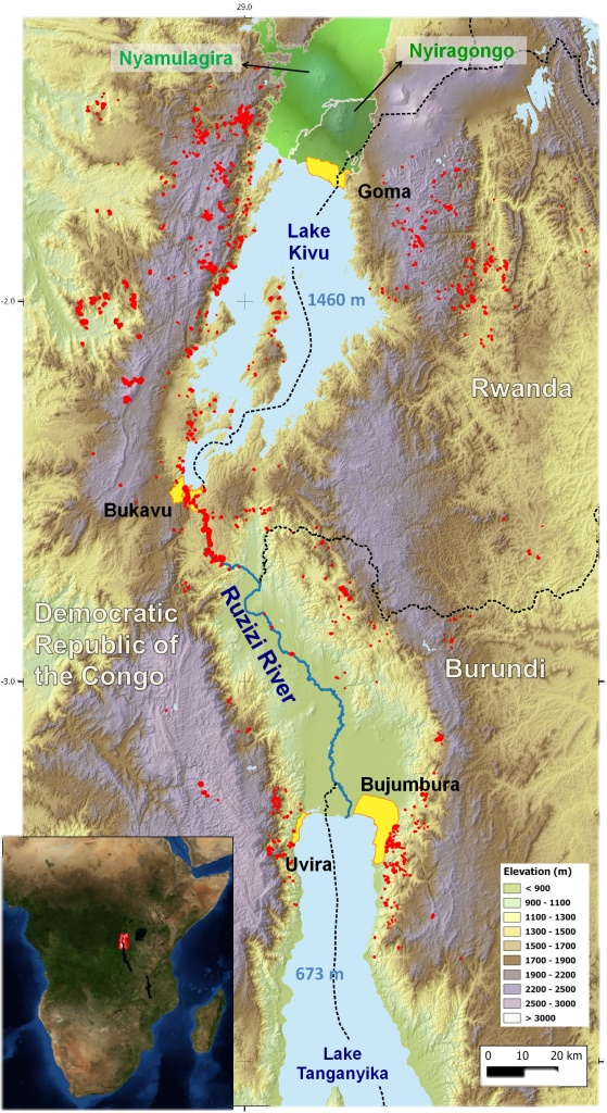
- The area has one of the highest population densities of Africa, urban expansion is very fast and anthropogenic pressure high (e.g., in Rwanda, the population density raised from 183 inh./km2 in 1978 to 415 inh./km2 in 2012 whereas the density for the whole continent is only of 39 inh./km2). Bukavu, Bujumbura, and Goma are cities with a current population of approximately 800,000 each, while in the colonial period, only a few thousands lived in these cities [1]. That population increase as a drastic effect in urban areas but also in rural areas where land conflicts are a real issue;
- A large majority of the population relies on agriculture; a significant part of the population is directly or indirectly related to the mining sector and both are contributing to land degradation.
- The area is at the border between three countries (with different governance policies and socioeconomic characteristics);
- Landscape is diverse (mountains, lakes, rivers, volcanoes) and soil and climate are very favorable for agriculture expansion;
- The area is affected by years of conflicts that in turn are jeopardizing the socio-economic development and impacting LULC (migration, land pressure on natural parks, mine control);
- Natural triggering and predisposing factors such as heavy rainfall, tectonic activity, and steep topography favor the occurrence of landslides and soil erosion processes (included large gullying) [2, 3]. In addition, Nyamulagira and Nyiragongo are two very active volcanoes and a source of various hazards (lava flow, toxic gas release) [4, 5, 6]. The volcanic risk and the lava flows, in particular, are adding more pressure on land use planning in the region of Goma;
- RMCA has developed a very strong expertise on the region over the last decade and has collected unprecedented datasets for similar environments;
- RMCA and ULB have developed a large network involving local institutions and the civil society in the framework of the GeoRisCA project.
References
[1] Michellier, C., et al., 2016. Contextualizing vulnerability assessment: a support to geo-risk management in central Africa. Natural Hazards 82, 27-42
[2] Maki Mateso, J.-C., Dewitte, O., 2014. Towards an inventory of landslide processes and the elements at risk on the Rift flanks West of Lake Kivu (DRC). Geo-Eco-Trop 38, 137–154.
[3] Jacobs, L., et al., M., 2016. The Rwenzori Mountains, a landslide-prone region? Landslides 13, 519–536.
[4] Smets, B., et al., 2010a. Dry gas vents (“mazuku”) in Goma region (North-Kivu, Democratic Republic of Congo): Formation and risk assessment. Journal of African Earth Sciences 58, 787–798.
[5] Smets, B., et al., 2015. Spatio-temporal dynamics of eruptions in a youthful extensional setting: Insights from Nyamulagira Volcano (D.R. Congo), in the western branch of the East African Rift. Earth-Science Reviews 150, 305–328.
[6] Smets, B., et al., 2016. Gas piston activity of the Nyiragongo lava lake: First insights from a Stereographic Time-Lapse Camera system. Journal of African Earth Sciences.